The Challenge
Los Angeles County is a biodiversity hotspot that harbors over 4,000 species of plants and animals. The most populous county in the nation, L.A. County offers a unique environment where more than 10 million people coexist with wildlife. The biodiversity of L.A. County provides many benefits to people, including air and water purification, food security and mental/physical well-being. But land development and climate change threaten the county’s species, their habitats, and the region's ecosystem. With 1 million animal and plant species globally facing extinction due to human activity, efforts to better understand the factors that shape biodiversity in Los Angeles could help shape global conservation efforts.
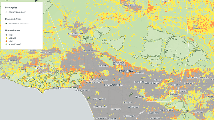
The Solution
The research team created the first publicly available online atlas of biodiversity patterns in L.A. County. The atlas enables users to explore how geography, climate and human impacts shape where key plant and animal species live, and how the county’s habitats could change due to predicted changes in climate and land use by 2050. Users can enter any street address in the county and visualize, for example, how likely they are to come across a mountain lion or black bear. Thus, it helps scientists and residents alike better understand Los Angeles' unique environment, interactively.
Ultimately, the atlas aims to contribute to improving conservation and management practices to sustain and preserve the richness of biological diversity in L.A. County while also promoting public engagement.
Results
- Many parts of L.A. County — Santa Monica and the City of Los Angeles in particular — have become greener since 2000.
- Light pollution has decreased within the Santa Monica Mountain National Recreational Area and San Gabriel Mountains over the past 20 years. This reflects the success of efforts by the National Park Service and other federal and state agencies to reduce light pollution and ecological harm from other human activity in protected areas.
- The first bird biodiversity map of L.A. County is created as a part of the atlas to depict the patterns of bird species richness. It also shows areas where the species of conservation concern inhabit. These are endangered or threatened birds that will continue to need protection, management and habitat restoration. Users can toggle layers for comparison and to learn more about the overall habitat health within the county.
- Average temperatures in L.A. County are predicted to increase by at least 1.9 degrees Celsius (3.4 degrees Fahrenheit) by 2050. In some areas farther inland, average temperatures could even increase by an average of 3.9 degrees Celsius (about 7 degrees Fahrenheit).
Next Steps
Conservation analyses will be undertaken in 2020 to promote future policy recommendations for conservation and restoration. Development of a companion guide to the Biodiversity Atlas is in progress.
Publications and Reports
Dimson, M., Lynch, S. C., & Gillespie, T. W. (2019). Using biased sampling data to model the distribution of invasive shot-hole borers in California. Biological Invasions, 21(8), 2693-2712. doi:10.1007/s10530-019-02010-z
Dong, C., Macdonald, G., Okin, G. S., & Gillespie, T. W. (2019). Quantifying Drought Sensitivity of Mediterranean Climate Vegetation to Recent Warming: A Case Study in Southern California. Remote Sensing, 11(24), 2902. doi:10.3390/rs11242902
Dong, C., Macdonald, G. M., Willis, K., Gillespie, T. W., Okin, G. S., & Williams, A. P. (2019). Vegetation Responses to 2012–2016 Drought in Northern and Southern California. Geophysical Research Letters, 46(7), 3810-3821. doi:10.1029/2019gl082137
Gillespie, T. W., Ostermann-Kelm, S., Dong, C., Willis, K. S., Okin, G. S., & Macdonald, G. M. (2018). Monitoring Changes of NDVI in Protected Areas of Southern California. Ecological Indicators, 88, 485-494. doi:10.1016/j.ecolind.2018.01.031
Okin, G. S., Dong, C., Willis, K. S., Gillespie, T. W., & Macdonald, G. M. (2018). The Impact of Drought on Native Southern California Vegetation: Remote Sensing Analysis Using MODIS-Derived Time Series. Journal of Geophysical Research: Biogeosciences, 123(6), 1927-1939. doi:10.1029/2018jg004485
Pincetl, S., Gillespie, T. W., Pataki, D. E., Porse, E., Jia, S., Kidera, E., . . . Choi, D. (2019). Evaluating the Effects of Turf-Replacement Programs in Los Angeles. Landscape and Urban Planning, 185, 210-221. doi:10.1016/j.landurbplan.2019.01.011
Pincetl, S., Porse, E., Mika, K. B., Litvak, E., Manago, K. F., Hogue, T. S., . . . Gold, M. (2018). Adapting Urban Water Systems to Manage Scarcity in the 21st Century: The Case of Los Angeles. Environmental Management, 63(3), 293-308. doi:10.1007/s00267-018-1118-2
Research Team
Thomas Gillespie
Geography, Social Sciences
Institute of the Environment & Sustainability
tg@geog.ucla.edu
Ryan Harrigan
Institute of the Environment & Sustainability
iluvsa@ucla.edu
Thomas Smith
Ecology & Evolutionary Biology, Life Sciences
Institute of the Environment & Sustainability, Center for Tropical Research
tbsmith@ucla.edu
Monica Dimson
Geography
mdimson@ucla.edu


